- Basics/Related Info
- GOES-R 101
- GOES-R: Benefits of Next-Generation Environmental Monitoring
- GOES-R Fact Sheets
- Training By Subject
- Aerosols/Air Quality/Atmospheric Composition
- Aviation
- Climate
- Clouds
- Convection
- Fire
- General Satellite Meteorology
- Hydrology
- Imagery
- Instruments
- Lightning
- Space Weather
- Winds
- By Institute


Training: Clouds
Click on the thumbnail images or links below to launch/redirect to each training course.
NASA’s Short-term Prediction Research and Transition Center (SPoRT)
![]() NASA’s Short-term Prediction Research and Transition Center (SPoRT) provides training about specific products, discussing the strengths and weaknesses, with the goal of successfully transitioning products to operations. This training is built from surveys and direct communication with our partners. With this paradigm, the forecasters are an integral component of the transition process and not a passive recipient of data.
NASA’s Short-term Prediction Research and Transition Center (SPoRT) provides training about specific products, discussing the strengths and weaknesses, with the goal of successfully transitioning products to operations. This training is built from surveys and direct communication with our partners. With this paradigm, the forecasters are an integral component of the transition process and not a passive recipient of data.
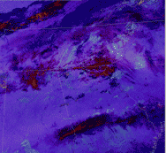
Valley fog through mid/high clouds in Southern Appalachians
Valley fog through mid/high clouds in Southern Appalachians: This 8-minute micro-lesson demonstrates the value of multispectral (i.e. RGB imagery) to the analysis of fog and low clouds in valleys of the southern Appalachians, particularly compared to channel differencing.
Virtual Institute for Satellite Integration Training (VISIT)
 Virtual Institute for Satellite Integration Training (VISIT) is a joint effort involving NOAA Cooperative Institutes, the National Environmental Satellite Data and Information Service (NESDIS), and the National Weather Service (NWS). The primary mission of VISIT is to accelerate the transfer of research results based on atmospheric remote sensing data into NWS operations using distance education techniques. Training sessions include topics on satellite meteorology, severe weather, climate, numerical weather prediction, and more.
Many of these modules were developed in collaboration with the Cooperative Institute for Meteorological Satellite Studies (CIMSS) and the Cooperative Institute for Research in the Atmosphere (CIRA). VISIT also provides satellite chats to demonstrate satellite products that can be applied to operational forecasting and identify new training topics based on specific participant needs. See the VISIT Training Calendar for upcoming teletraining sessions.
Virtual Institute for Satellite Integration Training (VISIT) is a joint effort involving NOAA Cooperative Institutes, the National Environmental Satellite Data and Information Service (NESDIS), and the National Weather Service (NWS). The primary mission of VISIT is to accelerate the transfer of research results based on atmospheric remote sensing data into NWS operations using distance education techniques. Training sessions include topics on satellite meteorology, severe weather, climate, numerical weather prediction, and more.
Many of these modules were developed in collaboration with the Cooperative Institute for Meteorological Satellite Studies (CIMSS) and the Cooperative Institute for Research in the Atmosphere (CIRA). VISIT also provides satellite chats to demonstrate satellite products that can be applied to operational forecasting and identify new training topics based on specific participant needs. See the VISIT Training Calendar for upcoming teletraining sessions.
VISIT Training Sessions:
VISIT offers a wide selection of satellite remote sensing training materials. See the VISIT Training Sessions webpage for a complete listing.
FDTD Satellite Application Webinars:
The National Weather Service Forecast Decision Training Division (FDTD) Satellite Application Webinars are peer-to-peer learning; staff from Weather Forecast Offices (WFOs), National Centers, Center Weather Service Units (CWSUs), and River Forecast Centers (RFCs) lead the presentations. The webinars to share how to apply GOES imagery with other datasets for a specific operational application.