- Basics/Related Info
- GOES-R 101
- GOES-R: Benefits of Next-Generation Environmental Monitoring
- GOES-R Fact Sheets
- Training By Subject
- Aerosols/Air Quality/Atmospheric Composition
- Aviation
- Climate
- Clouds
- Convection
- Fire
- General Satellite Meteorology
- Hydrology
- Imagery
- Instruments
- Lightning
- Space Weather
- Winds
- By Institute


Training: AEROSOLS/AIR QUALITY/ATMOSPHERIC COMPOSITION
Click on the thumbnail images or links below to launch/redirect to each training course.
Cooperative Program for Operational Meteorology, Education, and Training (Comet)
![]() The Cooperative Program for Operational Meteorology, Education, and Training supports, enhances, and stimulates the communication and application of scientific knowledge of the atmospheric and related sciences for the operational and educational communities. COMET’s web-based self-paced training materials serve earth science education and training needs by providing interactive experiences for learners at a distance. Experts at both the Cooperative Institute for Meteorological Satellite Studies (CIMSS) and the Cooperative Institute for Research in the Atmosphere (CIRA) contributed to many of these lessons.
The Cooperative Program for Operational Meteorology, Education, and Training supports, enhances, and stimulates the communication and application of scientific knowledge of the atmospheric and related sciences for the operational and educational communities. COMET’s web-based self-paced training materials serve earth science education and training needs by providing interactive experiences for learners at a distance. Experts at both the Cooperative Institute for Meteorological Satellite Studies (CIMSS) and the Cooperative Institute for Research in the Atmosphere (CIRA) contributed to many of these lessons.
Atmospheric Dust:
Atmospheric Dust: Atmospheric dust storms are common in many of the world's semi-arid and arid regions and can impact local, regional, and even global weather, agriculture, public health, transportation, industry, and ocean health. This module takes a multifaceted approach to studying atmospheric dust storms. This module is also available in French and Spanish.
Recognition and Impact of Vorticity Maxima and Minima in Satellite Imagery
Recognition and Impact of Vorticity Maxima and Minima in Satellite Imagery: Vorticity maxima and minima signatures are common features of the atmosphere. They indicate areas of ascending and descending circulation and atmospheric forcing and can be used to diagnose dynamic features such as the axis of maximum winds and deformation zones. This module provides insight on the analysis of these dynamic atmospheric features using Meteosat Second Generation (MSG) satellite imagery.
Satellite Monitoring of Atmospheric Composition
Satellite Monitoring of Atmospheric Composition: This module provides an overview of the use of satellites in monitoring of atmospheric composition to provide important information for a number of applications, including stratospheric ozone monitoring, long-range pollutant transport, biomass burning, air quality monitoring and forecasting, and climate change.
Satellite Feature Identification: Atmospheric Rivers
Satellite Feature Identification: Atmospheric Rivers: This module presents the global moisture transport phenomenon known as the atmospheric river (AR). ARs are responsible for transporting the majority of maritime moisture from low to middle latitudes.
Satellite Feature Identification: Deformation Zone Analysis
Satellite Feature Identification: Deformation Zone Analysis: The quick analysis of deformation zones provides an overview of system-relative atmospheric circulations. Since deformation is a primary factor in frontogenesis and frontolysis, understanding of these system-relative circulations is crucial to the diagnosis of atmospheric processes and weather prediction. This module is also available in Spanish and French.
Satellite Feature Identification: Deformation Zone Diagnosis
Satellite Feature Identification: Deformation Zone Diagnosis: Following an analysis of the main features of a deformation zone, the diagnosis of temporal and spatial changes in these features can be used to deduce underlying meteorological processes and their progression. In turn, this knowledge can then be used in the forecast process to adjust the forecast accordingly. This module is also available in French.
Satellite Feature Identification: Deformation Zone Distribution
Satellite Feature Identification: Deformation Zone Distribution: The distribution of vorticity centres along an axis of maximum winds follows a fairly predictable pattern based on the characteristics of the flow. By diagnosing these characteristics, the meteorologist is able to quickly deduce the location and relative intensities of the associated vorticity centres as well as the relative sizes of the associated circulations.
NASA’s Short-term Prediction Research and Transition Center (SPoRT)
![]() NASA’s Short-term Prediction Research and Transition Center (SPoRT) provides training about specific products, discussing the strengths and weaknesses, with the goal of successfully transitioning products to operations. This training is built from surveys and direct communication with our partners. With this paradigm, the forecasters are an integral component of the transition process and not a passive recipient of data.
NASA’s Short-term Prediction Research and Transition Center (SPoRT) provides training about specific products, discussing the strengths and weaknesses, with the goal of successfully transitioning products to operations. This training is built from surveys and direct communication with our partners. With this paradigm, the forecasters are an integral component of the transition process and not a passive recipient of data.
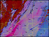
Dust RGB
Dust RGB: This micro-lesson demonstrates the value of applying Dust RGB imagery from the GOES-R ABI via an event from March 2017 in the U.S. Southwest. The Dust RGB is compared to traditional visible and infrared single-channel imagery to show the operational value of the multi-channel RGB imagery for analyzing blowing dust plumes during both day and night. Download Dust RGB Quick Guide (PDF).
Virtual Institute for Satellite Integration Training (VISIT)
 Virtual Institute for Satellite Integration Training (VISIT) is a joint effort involving NOAA Cooperative Institutes, the National Environmental Satellite Data and Information Service (NESDIS), and the National Weather Service (NWS). The primary mission of VISIT is to accelerate the transfer of research results based on atmospheric remote sensing data into NWS operations using distance education techniques. Training sessions include topics on satellite meteorology, severe weather, climate, numerical weather prediction, and more.
Many of these modules were developed in collaboration with the Cooperative Institute for Meteorological Satellite Studies (CIMSS) and the Cooperative Institute for Research in the Atmosphere (CIRA). VISIT also provides satellite chats to demonstrate satellite products that can be applied to operational forecasting and identify new training topics based on specific participant needs. See the VISIT Training Calendar for upcoming teletraining sessions.
Virtual Institute for Satellite Integration Training (VISIT) is a joint effort involving NOAA Cooperative Institutes, the National Environmental Satellite Data and Information Service (NESDIS), and the National Weather Service (NWS). The primary mission of VISIT is to accelerate the transfer of research results based on atmospheric remote sensing data into NWS operations using distance education techniques. Training sessions include topics on satellite meteorology, severe weather, climate, numerical weather prediction, and more.
Many of these modules were developed in collaboration with the Cooperative Institute for Meteorological Satellite Studies (CIMSS) and the Cooperative Institute for Research in the Atmosphere (CIRA). VISIT also provides satellite chats to demonstrate satellite products that can be applied to operational forecasting and identify new training topics based on specific participant needs. See the VISIT Training Calendar for upcoming teletraining sessions.
VISIT Training Sessions:
VISIT offers a wide selection of satellite remote sensing training materials. See the VISIT Training Sessions webpage for a complete listing.
FDTD Satellite Application Webinars:
The National Weather Service Forecast Decision Training Division (FDTD) Satellite Application Webinars are peer-to-peer learning; staff from Weather Forecast Offices (WFOs), National Centers, Center Weather Service Units (CWSUs), and River Forecast Centers (RFCs) lead the presentations. The webinars to share how to apply GOES imagery with other datasets for a specific operational application.