GOES-R Series News | 2022
-
December 29, 2022: The Top Satellite Images from 2022
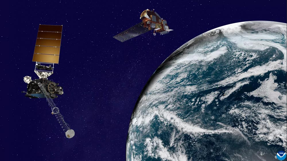
Artist’s rendering of a NOAA GOES satellite (left) and a NOAA JPSS satellite (right) orbiting Earth. Image not to scale. NOAA satellites see our planet from a unique and captivating perspective. Every year, our satellites see the beauty and wrath of Mother Nature unfold beneath them—devastating hurricanes, raging wildfires, erupting volcanoes—as well as the changing seasons, ocean color and nighttime lights. And their scope isn’t just limited to Earth; NOAA satellites can also capture images of our Moon and the Sun as we all spin our way through our place in space. View NOAA’s list of most compelling images from 2022 as seen from orbit by NOAA’s satellites.
-
December 06, 2022: Earth from Orbit: Mauna Loa Erupts for First Time Since 1984
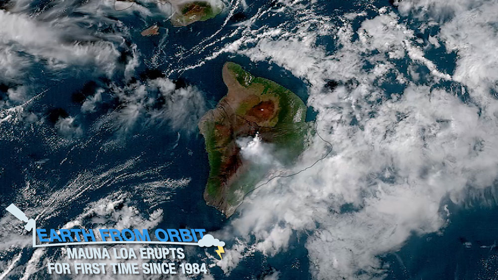
On Nov. 28, 2022, the Mauna Loa volcano, located on Hawaii’s Big Island, began erupting for the first time since 1984. The volcano began spewing ash and debris from its summit after a series of earthquakes and lava was ejected to heights of up to 148 feet on Nov. 29. As of Dec. 6, The Northeast Rift Zone eruption continued, with an active fissure feeding lava flow downslope. NOAA satellites monitored the ongoing eruption, lava flow, ash plume, and sulfur dioxide emissions. Mauna Loa has erupted 33 times since 1893, making it the world’s most active volcano. NOAA satellites are critical for detecting volcanic activity, alerting those in harm’s way of an eruption, and monitoring the hazards associated with volcanic eruptions.
-
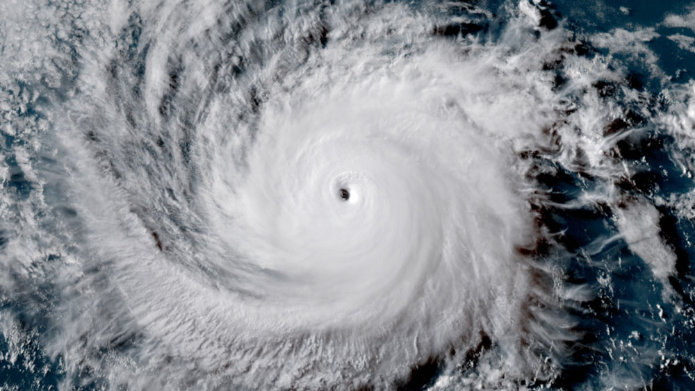
December 02, 2022: Earth from Orbit: The 2022 Atlantic Hurricane Season Comes to a Close

The 2022 Atlantic hurricane season officially came to a close on Nov. 30. This season produced 14 named storms, of which eight became hurricanes and two intensified to major hurricanes. This season was also defined by a rare mid-season pause in storms that scientists believe was preliminarily caused by increased wind shear and suppressed atmospheric moisture high over the Atlantic Ocean. After a quiet period in August, activity ramped up in September with seven named storms, including the two major hurricanes — Fiona and Ian — seen this season. The season also included a rare late-season storm with Hurricane Nicole making landfall on November 10 along the east coast of Florida. NOAA satellites constantly monitor the Atlantic hurricane basin and provided valuable data and imagery to forecasters for tracking the development, movement, and intensity of tropical cyclones this season.
December
-
November 21, 2022: NOAA’s GOES-U Completes Thermal Vacuum Testing

GOES-U is lowered into the thermal vacuum chamber. Photo credit: Lockheed Martin NOAA’s GOES-U, the final satellite in the GOES-R Series of advanced geostationary environmental satellites, recently completed thermal vacuum (TVAC) testing as part of a rigorous assessment program to ensure the satellite can withstand the harsh conditions of launch and orbiting 22,236 miles above Earth’s equator. The testing is taking place at Lockheed Martin Space’s Littleton, Colorado, facility, where GOES-U was built. GOES-U will undergo additional testing in the coming months to prepare for a planned April 2024 launch. Learn more about the testing and a new instrument that will fly on GOES-U, the Compact Coronagraph.
-
November 16, 2022: GOES-R System Program Director Pam Sullivan Honored with Presidential Rank Award
GOES-R System Program Director Pam Sullivan is the recipient of a 2022 Presidential Rank Award, one of the most prestigious awards in the federal career civil service. Chosen by President Biden, the Presidential Rank Awards recognize the hard work and important contributions of dedicated civil servants in the American federal workforce. Sullivan was honored with the Distinguished Executive Award for her sustained exceptional leadership, accomplishments, and service. Only 1% of the Senior Executive Service may receive the Distinguished rank. Congratulations Pam!
November
-
October 21, 2022: Earth from Orbit: Wildfires Erupt in the Pacific Northwest
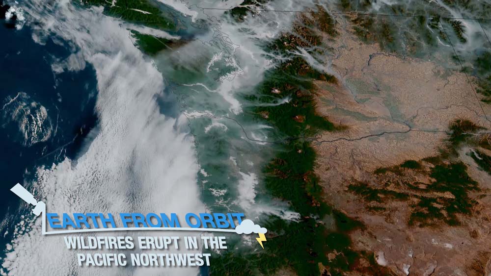
As cooler temperatures descend across parts of North America, NOAA satellites observed fires erupting in the Pacific Northwest this month. Warm, dry and windy conditions brought some of the driest October weather conditions to the region, increasing the risk of wildfires. Since Jan. 1, 2022, 56,710 wildfires have burned 7,022,627 acres around the country. This is the most wildfires reported to date in the past 10 years. Currently, there are more than 333,213 acres burning across Oregon, the largest total area of any state. NOAA satellites provide potentially life-saving information in a dynamic fire environment. GOES East and GOES West frequently detect fires before they are spotted on the ground, which is particularly important in remote areas. The satellites also track fires in real time, identify and track smoke, and determine a fire’s size and temperature. Suomi-NPP and NOAA-20 detect smaller and lower-temperature fires and also provide nighttime fire detection. The data from these satellites is also critical to smoke models used by fire crews, first responders, and air traffic controllers. As conditions remain warm and dry, NOAA satellites remain on watch for wildfires.
-
October 14, 2022: Third Quarter 2022 GOES-R/GeoXO Newsletter
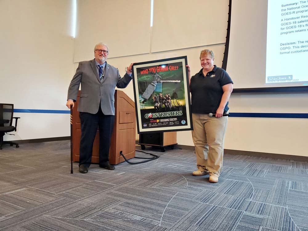
GOES-R system program director Pam Sullivan presents Greg Marlow, NOAA OSPO director, with a GOES-T poster to commemorate the satellite handover The GOES-R/GeoXO quarterly newsletter for July – September 2022 is now available. Congratulations to the team for completing GOES-18 post-launch testing and preparing the satellite for early operations! Our mission operations team completed a successful GOES-17/18 “interleave” period, delivering operational GOES-18 Advanced Baseline Imager (ABI) data to forecasters during the “warm” periods that degrade some GOES-17 (GOES West) imagery. GOES West data users have expressed appreciation for this novel solution to get them the GOES-18 ABI data early and shared how it has helped them with forecasts and warnings. GOES-18 has been handed over to NOAA’S Office of Satellite and Product Operations, and after additional product testing, it will go into operational service as GOES West in January 2023. GOES-U is fully integrated and beginning environmental testing. And GeoXO is moving full steam ahead toward Milestone 2 after completing the System Requirements Review in August. Our team continues to meet the mission and deliver life-saving technology and science to the nation.
-
October 04, 2022: Earth from Orbit: Hurricane Ian’s Path of Destruction
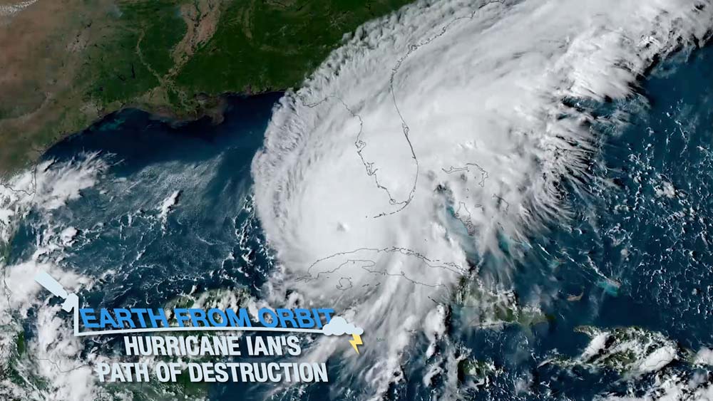
On Sept. 28, Hurricane Ian made landfall near Cayo Costa in southwestern Florida as a dangerous Category 4 storm after plowing a path of destruction through the Caribbean, bringing particularly heavy rainfall and dangerous surf to Jamaica, the Cayman Islands, and western Cuba. Ian thrashed parts of Florida’s western coast, bringing intense winds, heavy rainfall, and catastrophic storm surge. After crossing over the Florida peninsula, where it had weakened to a tropical storm, Ian strengthened again over the Atlantic to a Category 1 hurricane and made a second landfall near Georgetown, South Carolina on Sept. 30. NOAA satellite imagery helped forecasters pinpoint the center of circulation in real-time, monitor the storm’s intensity and movement, track thunderstorm activity both in the eyewall and in the tornado-producing outer rain bands, and determine when landfall would occur.
October
-
September 22, 2022: Earth from Orbit: Hurricane Fiona Leaves Wake of Destruction
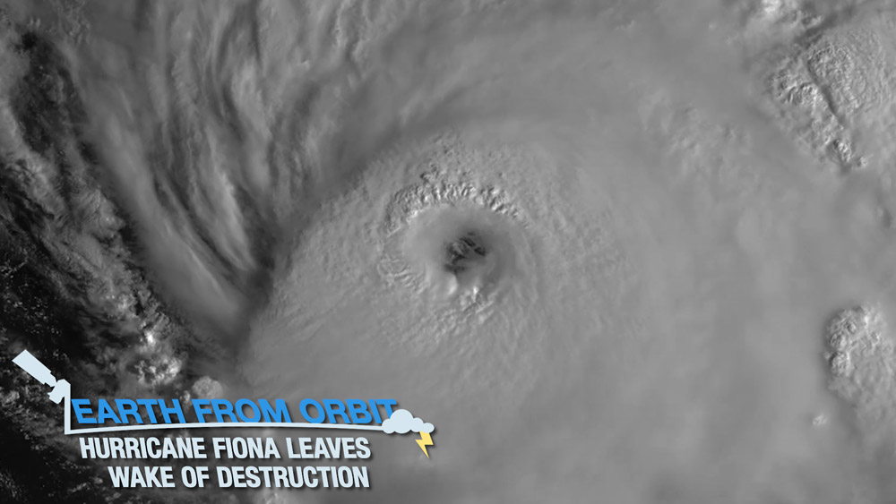
Hurricane Fiona, the first major storm of the Atlantic hurricane season, has been wreaking havoc, causing catastrophic damage across Puerto Rico, the Dominican Republic, and Turks and Caicos. The storm has caused devastating flooding and has damaged critical water and power infrastructure in its wake. Now, with sustained wind speeds of near 130 mph, Fiona is heading northward toward Bermuda as a Category 4 hurricane. NOAA satellites provide vital information for forecasting hurricanes and monitoring the location, movement and intensity of storms. As Fiona continues on its path, and other storms develop, NOAA satellites will be watching.
-
September 16, 2022: Earth from Orbit: Hurricane Kay Brings Rain to the Southwest While Wildfires Rage to the North
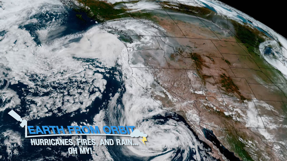
NOAA satellites have tracked a lot of activity across western North America this month. From wildfires, to a hurricane, to heavy rains in the drought-stricken region, satellite imagery has been vital in monitoring these events. Pacific moisture from Hurricane Kay brought heavy rain and flash flooding to areas in California and Arizona. The remnants of Kay provided temporary relief to some communities battling wildfires. Meanwhile, the Northwest continued to experience dry conditions and wildfires. No matter what phenomena occur, NOAA satellites provide critical data for monitoring hazardous situations.
-
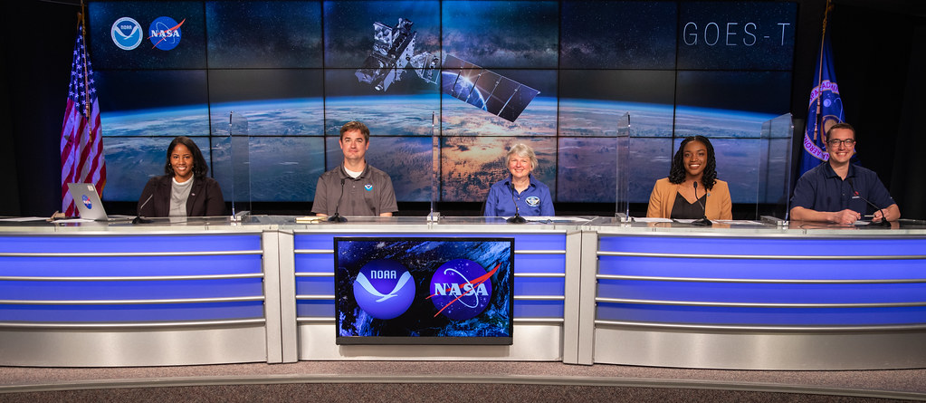
September 13, 2022: NOAA Your Place in Space Career Profile
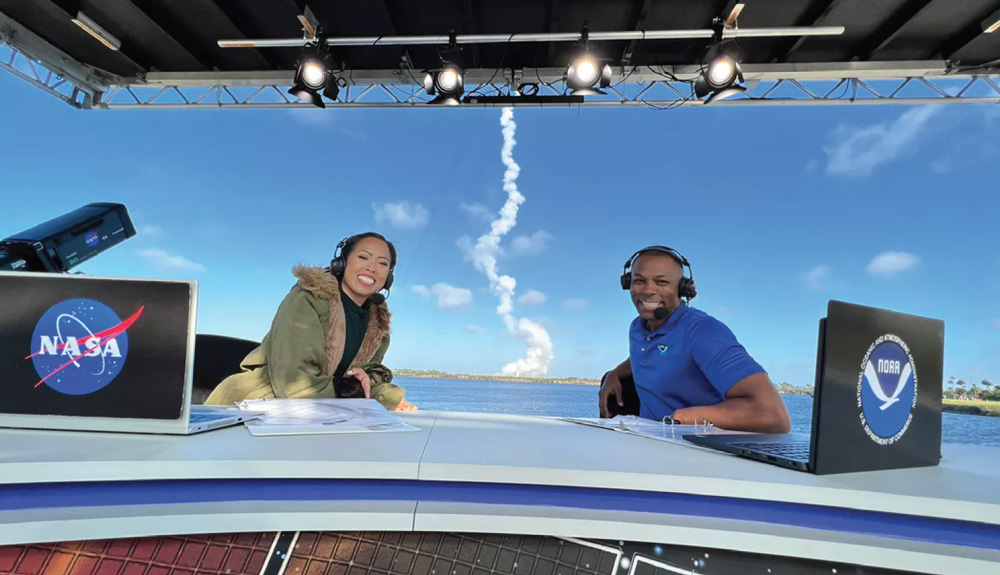
Kevin Fryar and NASA colleague sitting at broadcast desk during the GOES-T launch broadcast. Did you know that most people who have space-related careers are not astronauts or rocket scientists? Space missions, satellite programs, and scientific research require a large team of people with a variety of skills. NOAA spoke to a few team members about their space-related careers and the advice they’d give to young people reaching for the stars, including GOES-R/GeoXO Chief of Staff Kevin Fryar.
-
September 8, 2022: Earth from Orbit: First Atlantic Hurricanes of 2022 Arrive
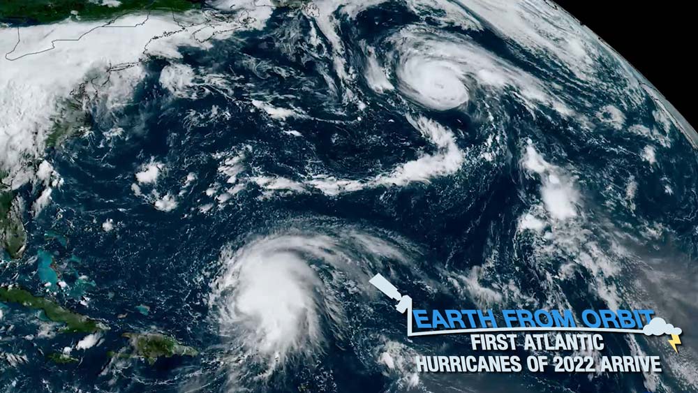
After a slow start to the 2022 Atlantic hurricane season, activity has ramped up with the first two hurricanes forming during the first week of September. The Atlantic went without a named from July 6 through Aug. 31. August passed without a named storm for the first time since 1997. Tropical Storm Danielle formed on Sept. 1 in the far North Atlantic. The storm gained strength unusually far north where hurricanes are rare. Record-warm ocean temperatures fueled Danielle, which strengthened into a hurricane on Sept. 2. Tropical Storm Earl developed east of the Northern Leeward Islands on Sept. 3, and brought heavy rains to Puerto Rico, the U.S. Virgin Islands and the Leeward Islands. Earl strengthened to hurricane status on the evening of Sept. 6 and is expected to pass southeast of Bermuda late on Sept. 8. NOAA satellites monitor the ocean and atmospheric conditions that lead to the development of tropical storms and hurricanes. Once a storm forms, the satellites provide critical data—such as location, movement, and intensity—to track the storms.
September
-
August 25, 2022: Remembering Hurricane Andrew 30 Years Later
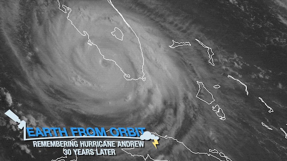
Aug. 24, 2022, marked the 30th anniversary of Hurricane Andrew’s landfall in southern Florida. Andrew was one of the most catastrophic hurricanes in U.S. history. Since Hurricane Andrew, dramatic advancements in technology have helped to better prepare for, predict, monitor, and respond to hurricanes. NOAA’s latest generation of satellites has revolutionized the way scientists and forecasters monitor and track tropical systems. They monitor the conditions that lead to hurricane formation, provide early warning that a storm is forming, monitor and track the movement of storms, and estimate storm intensity. NOAA satellites are our vigilant eyes in the sky, helping protect lives and property when hurricanes strike.
-
August 18, 2022: Earth from Orbit: When Lightning Strikes
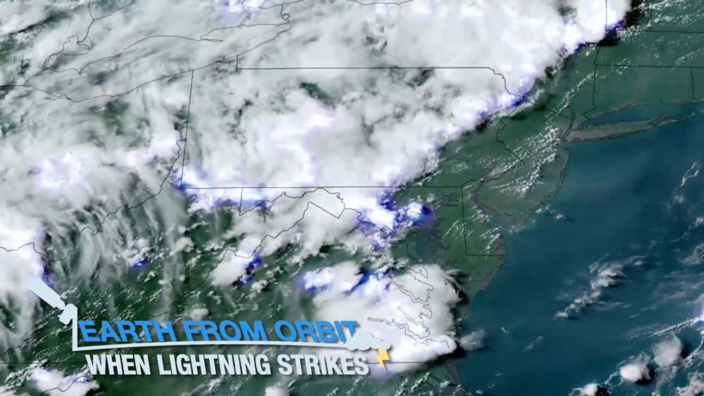
Lightning is a major public safety threat. Several incidents of injuries and fatalities from lightning strikes in early August 2022 highlight the importance of lightning safety and awareness. The GOES-R Geostationary Lightning Mapper (GLM) detects and maps lightning within storms. GLM can show forecasters areas where the risk of lightning strikes presents a public safety hazard, leading to fewer lightning-related injuries and deaths. GOES-16 and GOES-17 can not only detect current lightning activity, but their data can also help predict the occurrence of lightning in the future. Scientists are using an artificial intelligence (AI) model, called ProbSevere LightningCast to predict where lightning is most likely to occur up to 60 minutes in advance. As thunderstorms occur with a threat of lightning, NOAA satellites work with partners and decision-makers to keep the public safe and informed.
-
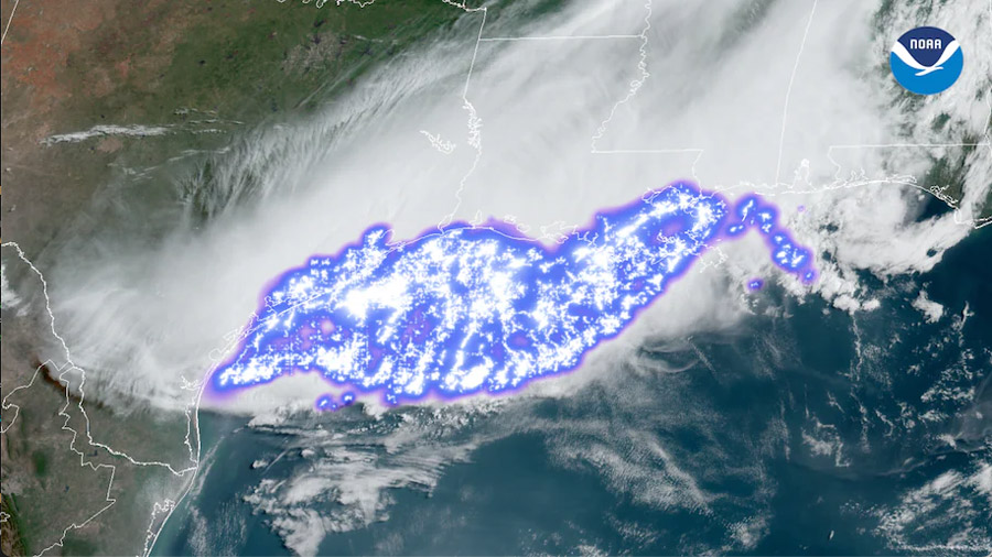
August 4, 2022: Earth from Orbit: Kentucky and Missouri Devastated by Flash Flooding
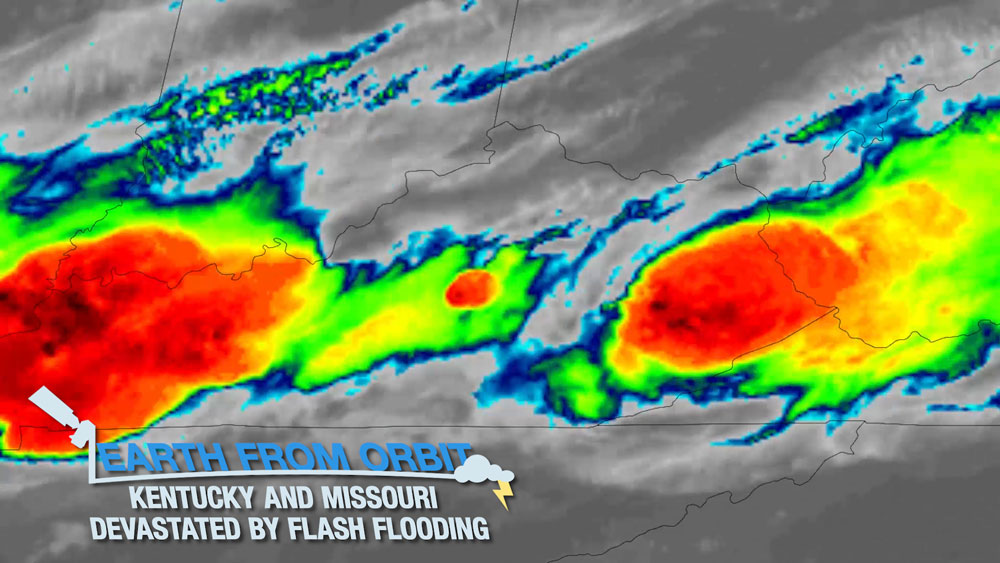
Hundreds of miles apart, but connected by the same weather system, urban St. Louis and rural Appalachia have recently experienced devastating flash flooding. NOAA satellites monitored the storms that produced the catastrophic flooding, measuring the amount of water vapor in the atmosphere, cloud top temperatures, and lightning activity. Scientists also use data collected NOAA satellites to produce flood maps to determine where flooding may be occurring. These maps help first responders decide where to send aid. When storm systems develop with the potential to cause flash flooding, NOAA satellites will be watching.
August
-
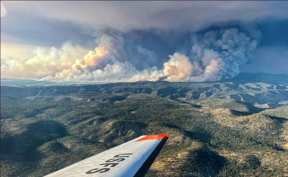
July 28, 2022: California’s Oak Fire Near Yosemite Spreads Rapidly
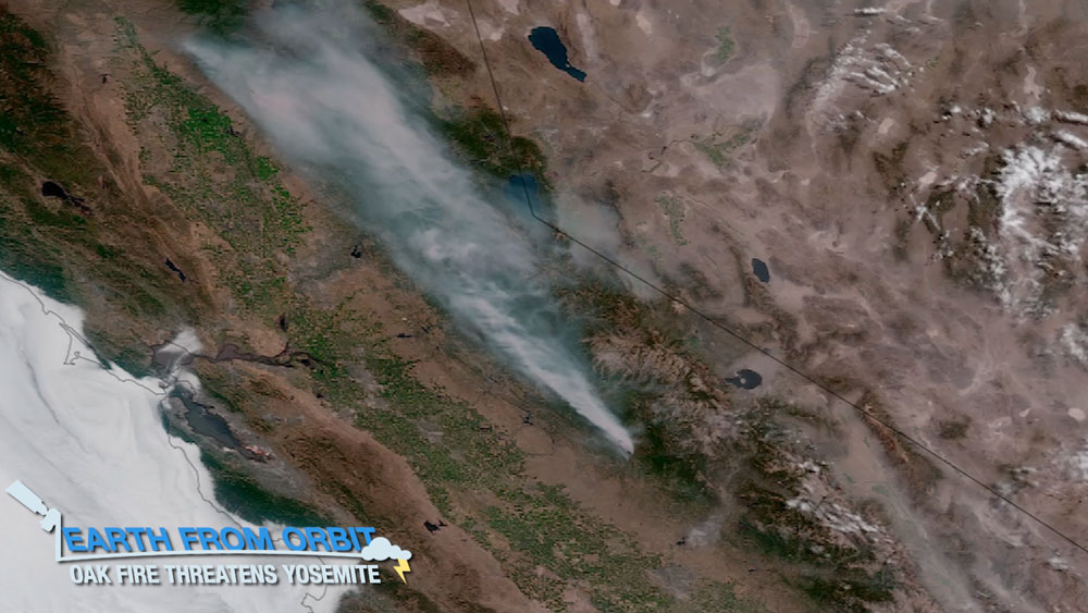
Strong winds and extremely dry conditions fueled a wildfire that ignited on July 22 near Yosemite National Park. The Oak Fire is currently the largest active wildfire in California, burning more than 18,800 acres. NOAA satellites are monitoring the rapidly spreading fire and providing critical data. GOES-17 is measuring the Oak Fire’s intensity, tracking its spread, and monitoring the movement of smoke in near real-time. As drought persists, and fire season ramps up, NOAA satellites will be watching and providing timely and potentially life-saving information.
-
July 28, 2022: NOAA Prepares Forecasters for GOES-18 Data
GOES-18 GeoColor image of Hurricane Darby in the Eastern Pacific Ocean on July 11, 2022. While NOAA’s GOES-18 undergoes post-launch testing (PLT) and calibration of its instruments and systems, the new satellite is in position to help forecasters during the height of the 2022 Pacific hurricane season. GOES-18 was moved to 137.0 degrees west longitude early in PLT so its Advanced Baseline Imager (ABI) data will be available to forecasters during the “warm” periods that degrade some GOES-17 (GOES-West) imagery during the height of hurricane season. NOAA implemented a unique solution to mitigate the loss of warm period GOES-17 imagery by delivering GOES-18 ABI data to GOES-West data users. Starting on Aug. 1, 2022, GOES-West data users will receive GOES-18 ABI data for operational use. This will be accomplished through a data “interleave” that will deliver GOES-18 ABI data with GOES-17 lightning mapper and space weather data through the GOES Rebroadcast and Product Distribution and Access data delivery systems. This period of data interleave will end on Sept. 6. A second period of data interleave will take place from Oct. 13 through Nov. 14 of this year.
-
July 19, 2022: NOAA Shares First Imagery from GOES-18 SUVI Instrument
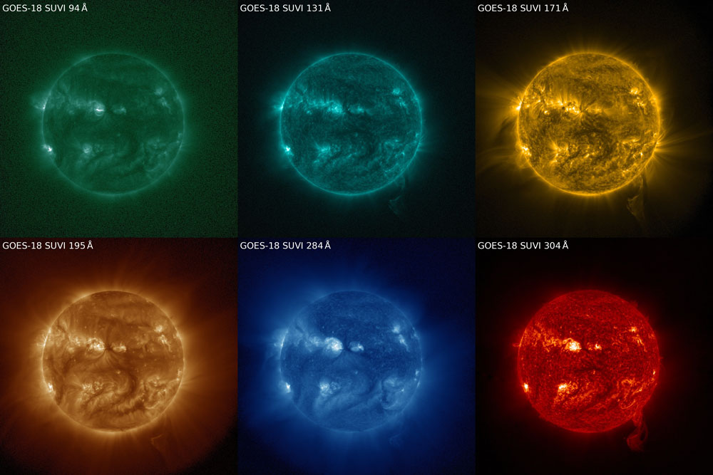
The GOES-18 SUVI captured a coronal mass ejection on July 10, 2022. The sun is seen SUVI's six extreme ultraviolet channels. The Solar Ultraviolet Imager, or SUVI, onboard NOAA’s GOES-18 satellite, which launched on March 1, 2022, began observing the sun on June 24, 2022. The sun’s 11-year activity cycle is ramping back up, meaning phenomena such as coronal mass ejections (CMEs) and solar flares are increasing in frequency. GOES-18’s SUVI captured a CME on July 10, 2022. SUVI monitors the sun in the extreme ultraviolet portion of the electromagnetic spectrum. Depending on the size and the trajectory of solar eruptions, the possible effects to near-Earth space and Earth’s magnetosphere can cause geomagnetic storms, which can disrupt power utilities and communication and navigation systems. These storms may also cause radiation damage to orbiting satellites and the International Space Station.
-
July 13, 2022: NOAA Shares First Data from GOES-18 EXIS Instrument
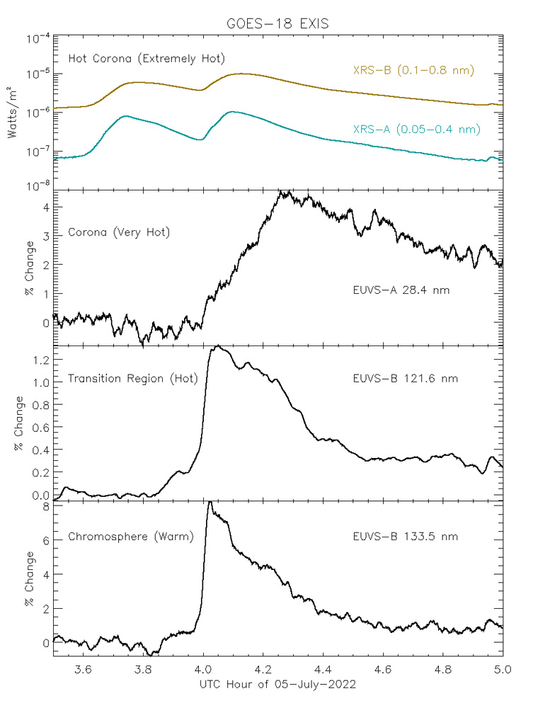
First GOES-18 EXIS data The Extreme Ultraviolet and X-ray Irradiance Sensors (EXIS) onboard NOAA’s GOES-18 satellite are powered on, performing well, and observing the sun. On July 5, 2022, EXIS observed a pair of moderate flares that erupted on the sun between 3:30 and 4:30 UTC. EXIS has two main sensors, the X-Ray Sensor (XRS), which measures soft X-rays, and the Extreme Ultraviolet Sensors (EUVS), which measure extreme ultraviolet light. The two flares appeared differently near Earth and demonstrate why EXIS observes light from the sun at multiple wavelengths. EXIS, with its multiple sensors, can observe and quantify the difference between the light from solar flares and help determine in real-time whether the flares will affect us on Earth.
-
July 13, 2022: Second Quarter 2022 GOES-R/GeoXO Newsletter
GOES-18 view from 136.8 degrees west longitude on June 7, 2022. Image credit: NOAA/NASA The GOES-R/GeoXO quarterly newsletter for April – June 2022 is now available. GOES-18 is doing well in post-launch testing, with the first imagery released from four of its instruments. GOES-18 is now operating near the GOES-West location, getting ready to provide operational Advanced Baseline Imager (ABI) data to forecasters during the GOES-17 warm period outages. The team did an excellent job making the novel ABI ‘interleave’ and cloud delivery techniques possible. GOES-U is also making great progress, with the System Integration Review complete, and Pre-Environmental Review happening in mid-July. GeoXO is ever more active, with Phase A studies awarded for three more instruments, and preparations in high gear for the System Requirements Review in August.
-
July 6, 2022: What Causes Lightning?
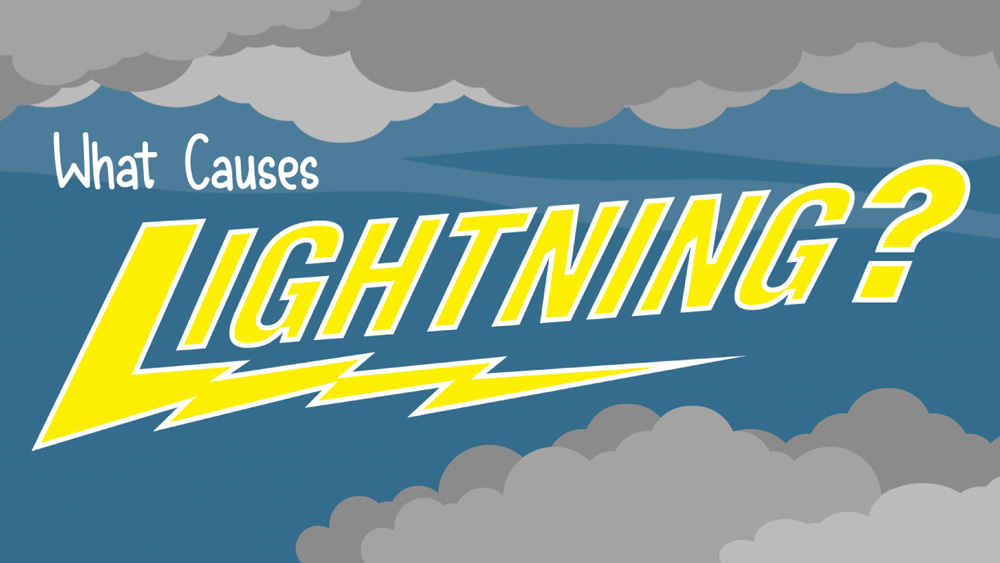
Lightning can be a beautiful—and scary—part of Earth’s weather. You probably have seen lightning in a thunderstorm, but do you know why lightning happens? Learn more in this new video from NOAA SciJinks.
July
-
June 30, 2022: Earth from Orbit: Alaska Ablaze
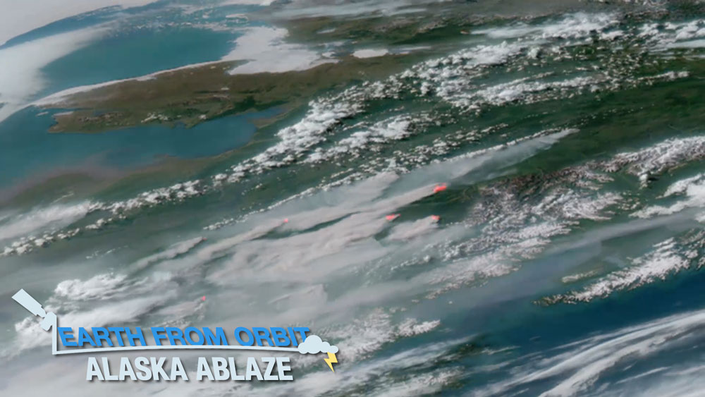
Throughout June 2022, NOAA satellites monitored wildfires in Alaska that have burned more than 1.6 million acres. Unusually hot and dry weather in the region increased the risk of fires. These conditions led to more than 300 fires in recent weeks, with many sparked by lightning. On May 31, lightning ignited the East Fork Fire and burned over 250,000 acres, making it one of the largest tundra fires on record. Meanwhile, the Lime Complex Fire has burned more than 600,000 acres in southwestern Alaska. As Alaska’s historic wildfire season continues, NOAA satellites are keeping watch.
-
June 24, 2022: Earth from Orbit: Summer Solstice
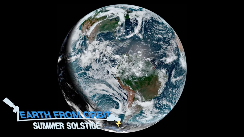
June 21 marked the official start of astronomical summer in the Northern Hemisphere. The summer solstice — the longest day and shortest night of the year — occurred at 5:14 a.m. EDT. The summer solstice is the moment the hemisphere reaches its greatest tilt toward the sun. As the Earth rotates on its axis, the North Pole experiences 24 hours of daylight, while the South Pole is obscured in darkness. NOAA’s GOES-16 and GOES-17 satellites constantly observe the same region of Earth, allowing a view of the terminator as it moves across the Western Hemisphere. The terminator is the edge between the shadows of nightfall and the sunlight of dusk and dawn. The slope of the terminator curve changes with the seasons.
-
June 14, 2022: Earth from Orbit: GOES-18 GOES West
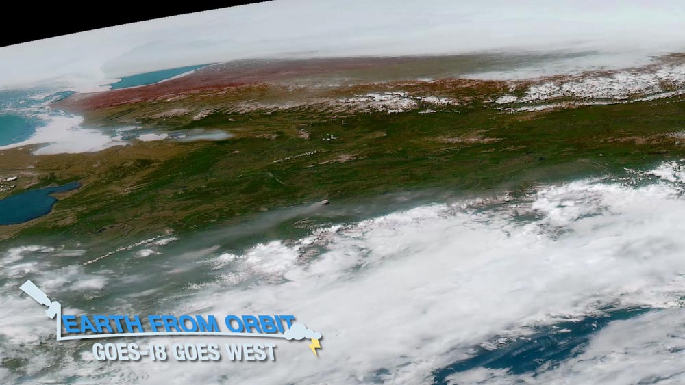
NOAA’s GOES-18 is now sending back data from its new post-launch testing position over the Pacific Ocean. From its new vantage point, GOES-18 can now see Alaska, Hawaii, and the Pacific Ocean all the way to New Zealand. This location allows it to monitor the northeastern Pacific, where many of the weather systems affecting the continental U.S. originate. GOES-18 has already seen a lot from its new location. Recently, the GOES-18 Advanced Baseline Imager (ABI) monitored a number of weather events, meteorological phenomena, and environmental hazards. The satellite tracked fire activity in Alaska, snow and the movement of fog and smoke. It monitored a low pressure system off the West Coast and severe thunderstorms in Colorado. GOES-18 also viewed mesmerizing von Kármán vortices off the coast of Isla Guadalupe and beautiful cloud formations over Hawaii. As GOES-18 continues post-launch testing, its ABI will provide critical information for eastern Pacific hurricane forecasters despite not yet being fully operational. After the completion of post-launch testing and checkout, NOAA plans for GOES-18 to replace GOES-17 as the operational GOES West satellite in early 2023.
-
June 9, 2022: Earth from Orbit: 2022 Hurricane Season Begins
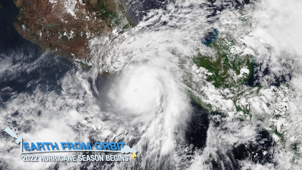
The 2022 hurricane season is officially underway. The eastern Pacific hurricane season began on May 15, while June 1 marked the beginning of the Atlantic hurricane season. NOAA satellites monitored the first named storms in each hurricane basin. Tropical Storm Agatha formed in the eastern Pacific Ocean on May 28 and rapidly intensified into a Category 2 hurricane. On May 30, Agatha became the strongest hurricane on record to make landfall along the Pacific coast of Mexico in the month of May. Remnants from Agatha helped fuel what would become the Atlantic’s first named tropical storm, Alex, which affected south Florida at the beginning of June. NOAA satellites provide vital information for forecasting hurricanes and monitoring the location, movement and intensity of storms. As the hurricane season ramps up, NOAA satellites are keeping watch.
-
June 9, 2022: NOAA Satellites Improve Estimates of Wildfire Smoke, Air Quality Predictions
A view of New Mexico’s Black Fire from an air attack on May 16, 2022. Photo credit: InciWeb A team of scientists from NOAA’s Satellite and Information Service (NESDIS) and South Dakota State University has developed more accurate forecasts to predict the impacts of wildfire smoke on air quality. The method known as Regional Hourly Advanced Baseline Imager (ABI) and Visible Infrared Imaging Radiometer Suite (VIIRS) Emissions, or RAVE, combines observations from instruments on NOAA’s geostationary and polar-orbiting weather satellites to calculate estimates of wildfire emissions.
-
June 2, 2022: Earth from Orbit: Flashy First Imagery from the GOES-18 Geostationary Lightning Mapper
On June 2, NOAA shared striking first imagery from the GOES-18 Geostationary Lightning Mapper (GLM). Recently, GLM monitored lightning activity within severe storms across the U.S. The instrument captured significant lightning activity in the derecho that moved across the Northern Plains on May 12-13. GLM helps forecasters identify intensifying storms and captures the evolution of individual storm cells that combine to form massive storm systems. Widespread weather events pose particular challenges for the aviation industry. GLM data helps pilots and air traffic controllers route flights to maximize safety and minimize economic impacts. GOES-18 is undergoing post-launch testing to prepare it for operations. NOAA plans for GOES-18 to begin operating as GOES West in early 2023.
-
June 1, 2022: GOES-16/17 Virtual Science Fair Winners Announced
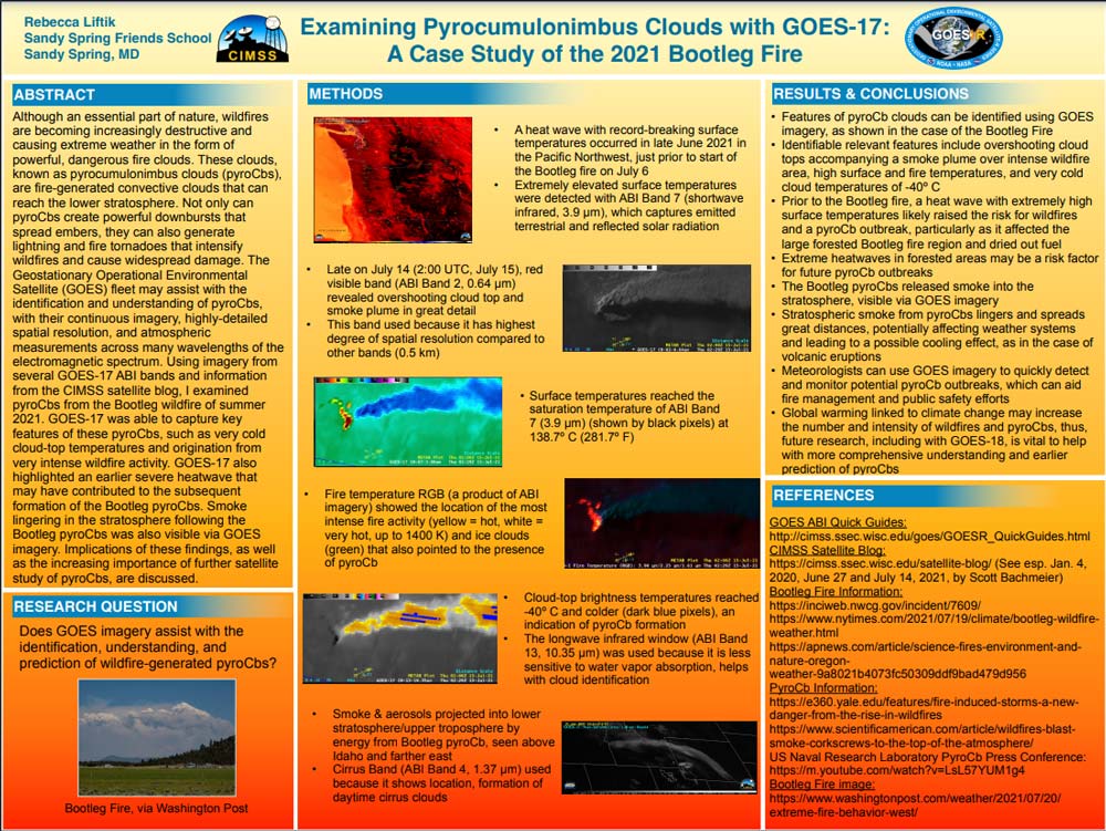
Winning high school submission: Examining Pyrocumulonimbus Clouds with GOES-17:
A Case Study of the 2021 Bootleg FireWinners of the 2022 GOES-16/17 Virtual Science Fair were announced on June 1. In this nationwide virtual science competition, students designed projects that used GOES 16/17 satellite data to investigate weather or natural hazards. Each individual/team shared their project through a scientific poster and a short video presentation. The winning high school project, by Rebecca Liftik of Sandy Spring Friends School in Sandy Spring, Maryland, examined pyrocumulonimbus clouds in the 2021 Bootleg Fire using GOES-17 data. The winning middle school project, from Eric Sun and Sean Jiang of Gilman Middle School in Baltimore, Maryland, studied the causes of the 2021 California wildfires using GOES-17 data.
June
-
May 11, 2022: Earth from Orbit: NOAA Debuts First Imagery from GOES-18
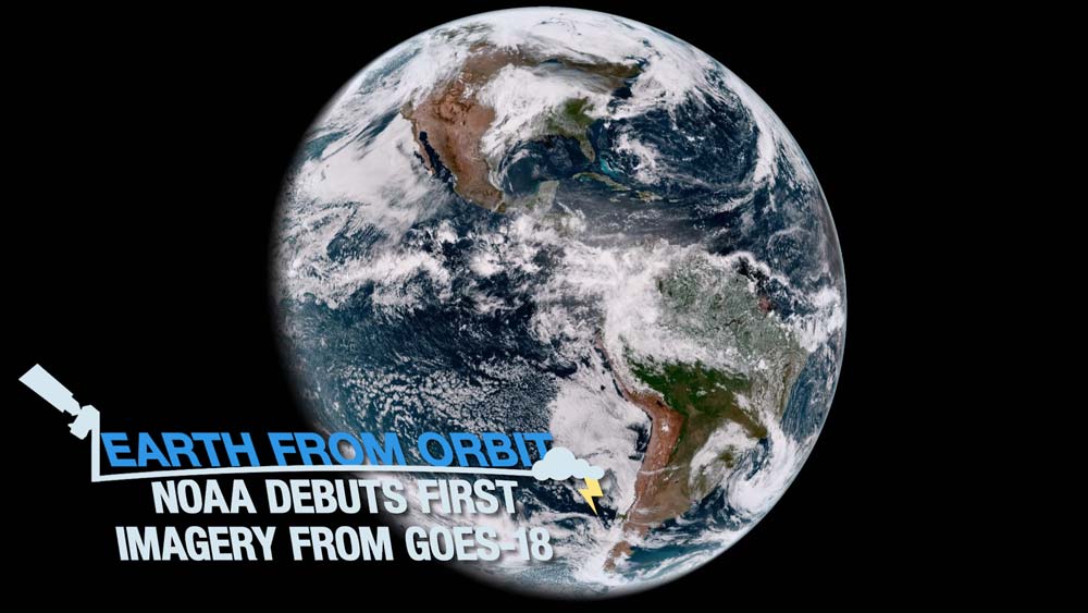
On May 11, 2022, NOAA shared the first images of the Western Hemisphere from its GOES-18 satellite. The satellite’s Advanced Baseline Imager (ABI) instrument recently observed a number of weather events, environmental phenomena, and striking views of Earth. Storms across east Texas produced large hail, strong wind gusts, and tornadoes. Farther west in New Mexico, strong winds resulted in large areas of blowing dust and expansion of large wildfires. Fog blanketed parts of Chile in South America, and clouds and some thunderstorms formed along sea breezes in the Yucatan and south Florida. GOES-18, launched on March 1, 2022, is currently undergoing post-launch testing in preparation for transitioning to operations as GOES West in early 2023.
-
May 4, 2022: NOAA Shares First Data from GOES-18 Magnetometer
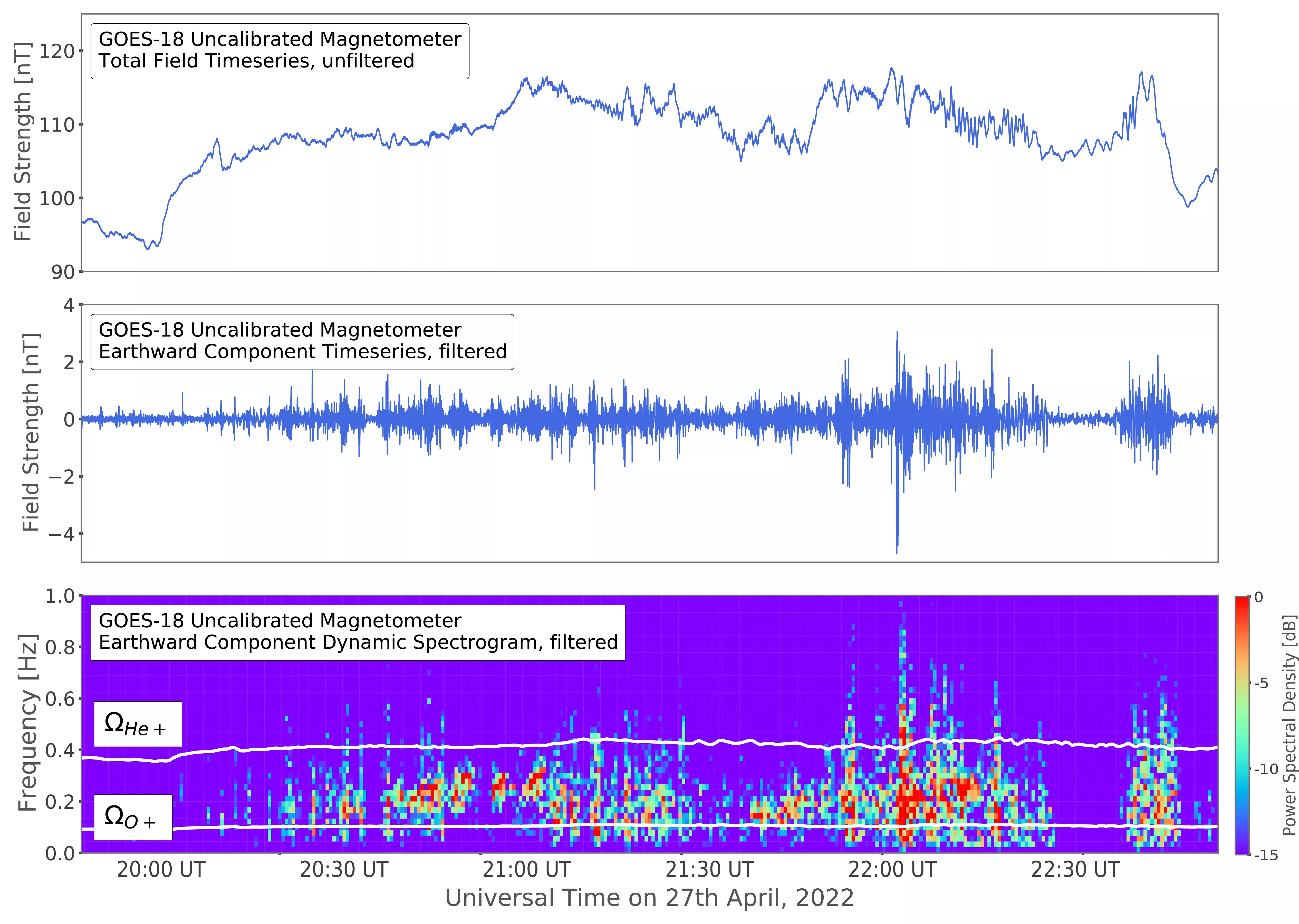
First GOES-18 GMAG data The Goddard Magnetometer (GMAG) instrument, launched aboard NOAA’s GOES-18 satellite on March 1, 2022, is now transmitting magnetic field measurements down to Earth. On April 27, 2022, the GOES-18 GMAG captured a space weather phenomenon known as plasma waves. These waves play a significant role in controlling the levels of dangerous energetic particles that cause damage to satellites and harm astronauts. The GOES-18 GMAG is an upgraded magnetometer instrument that offers improved measurements of Earth’s magnetic field over the magnetometers on GOES-16 and GOES-17.
-
May 3, 2022: NOAA Shares First Data from GOES-18 SEISS Instrument
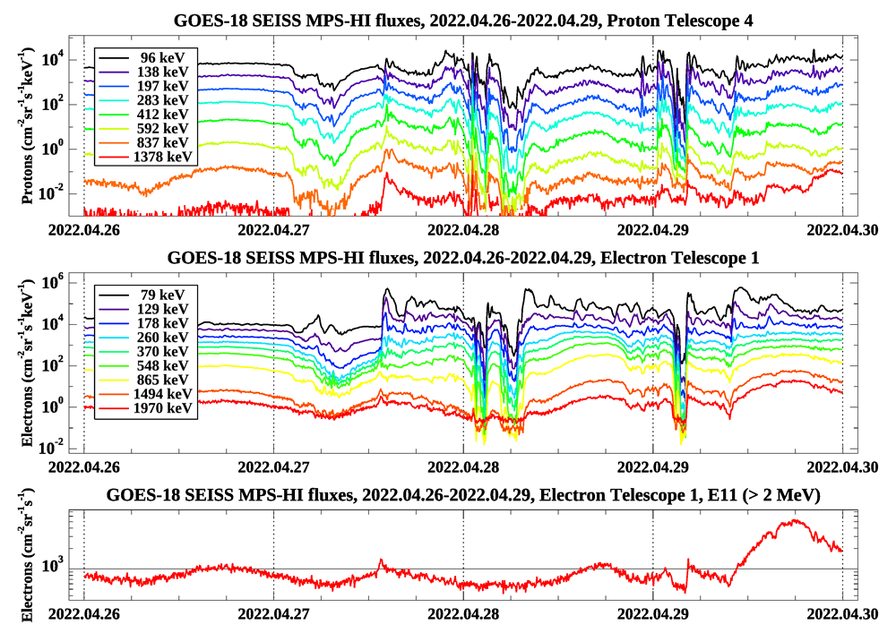
First GOES-18 SEISS data The Space Environment In-Situ Suite (SEISS) instrument onboard NOAA's GOES-18 satellite is now sending radiation data back to Earth. GOES-18 launched on March 1, 2022, and the SEISS sensors have been collecting data continuously since April 25, 2022. The GOES-18 SEISS detected a number of radiation belt disturbances on April 27-29, 2022. Shortly after these observations were seen by the GOES-18 SEISS, NOAA’s Space Weather Prediction Center (SWPC) issued an alert for a G1 (minor) geomagnetic storm, warning of possible risk to satellite systems due to charging.
May

-
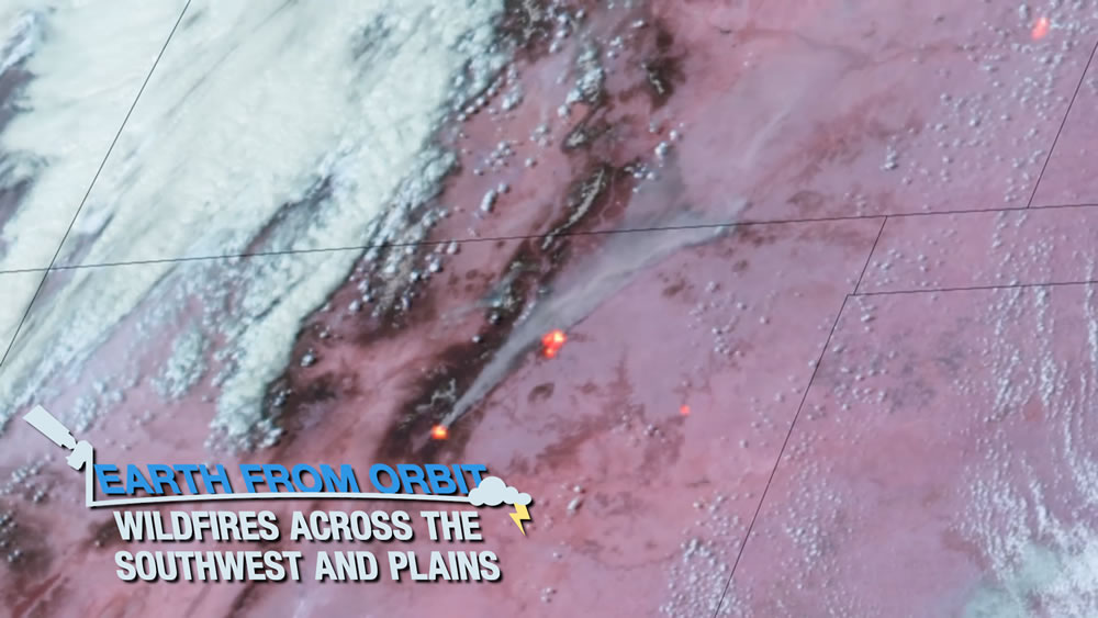
April 28, 2022: Earth from Orbit: Wildfires Across the Plains and Southwest
Since early April 2022, NOAA satellites have been watching wildfires burning across parts of the Southwest and Plains. The two largest fires located in northern New Mexico, the Calf Canyon and Hermits Peak Fires, have burned more than 60,000 acres. GOES-17 watched smoke billowing over the region and drifting to areas upwind bringing hazy skies to communities many miles away. GOES-17 and GOES-16 also detected hot spots from the fires in near-real time while providing information on the size and intensity of these fires. NOAA-20 and Suomi NPP captured daytime and nighttime images of the fires. They also took air quality measurements and tracked the movement and thickness of smoke over the region. As fire season starts earlier and ends later, NOAA satellites are keeping watch.
-
April 22, 2022: Earth from Orbit: Earth Day
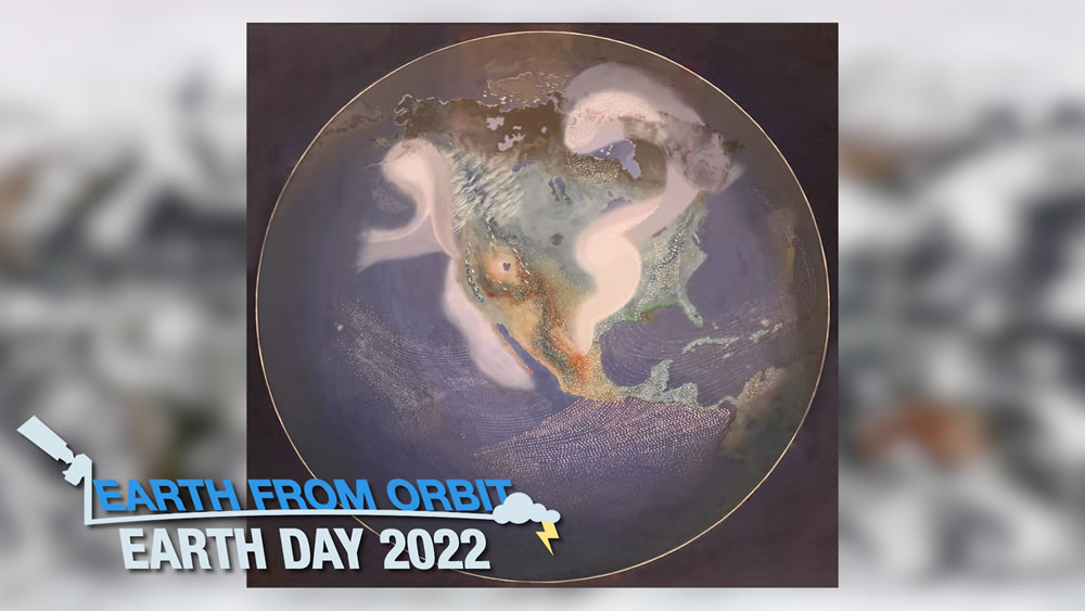
Before we had satellites, we could only imagine what the Earth looked like from above. Our view has come a long way, from changes in technology to how we understand Earth’s systems. Built upon NASA’s pioneering efforts, NOAA’s satellite program continues to improve Earth observations from space. Since 1970, NOAA satellites have monitored Earth's weather, environment, oceans and climate. As NOAA satellites continue to advance, they increase our understanding our planet, because every day at NOAA is Earth Day.
-
April 15, 2022: Earth from Orbit: Spring Snowstorm Hits U.S.
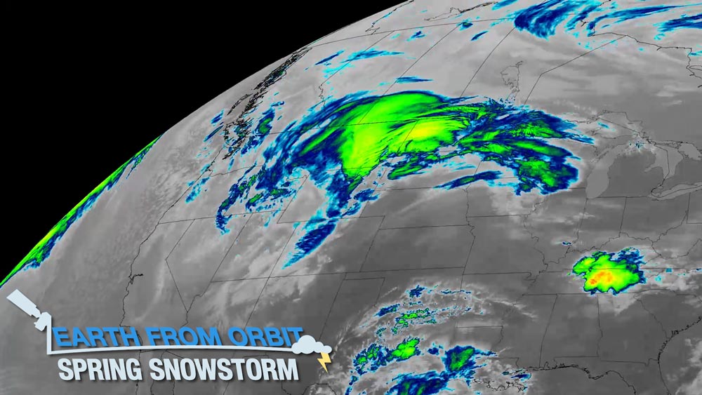
This week, NOAA satellites monitored a large storm system that brought winter weather to some regions and severe weather to others. GOES-17 watched as the system moved eastward across the Pacific Northwest where it brought snow. GOES-16 watched the progression of the storm as the cold air met with the warm humid air from the Gulf of Mexico. This clash of air masses led to severe weather in multiple states across the Midwest and South. The GOES-16 Geostationary Lightning Mapper watched as the storms produced frequent lightning as they marched eastward. The system produced more than 500 reports of damaging winds, large hail, and tornadoes throughout the central U.S. The storms finally wound down as the system reached the East Coast.
-
April 7, 2022: First Quarter 2022 GOES-R/GeoXO Newsletter

GOES-T lifts off from Space Launch Complex 41 at Cape Canaveral Space Force Station on March 1, 2022.
Photo credit: NASA/Kevin O’Connell & Kevin DavThe GOES-R/GeoXO quarterly newsletter for January – March 2022 is now available. Congratulations to the team on another successful launch! GOES-T lifted off on March 1, 2022, four years to the day after GOES-S launched. The satellite reached geostationary orbit on March 14 and is now GOES-18. Post-launch testing is now underway and GOES-18 is expected to take its place as the operational GOES West satellite in early 2023. Getting GOES-18 into orbit was a remarkable feat amid the COVID-19 pandemic. Looking forward, the team is busy with GOES-U integration and testing in preparation for launch in 2024 and progressing through GeoXO Phase A activities toward Milestone 2 later this year.
April
-
March 25, 2022: Earth from Orbit: Vernal Equinox
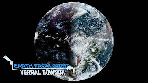
The vernal equinox on March 20, 2022, marked the beginning of astronomical spring in the Northern Hemisphere. The spring equinox results in nearly equal daylight and darkness across the planet. During an equinox, the terminator – the edge between the shadows of nightfall and the sunlight of dusk and dawn – is a straight north-south line over the equator. GOES-16 and GOES-17 constantly observe the same region of Earth, allowing a view of the terminator as it moves across the Western Hemisphere. Earth’s seasons change due to the tilt of the planet’s axis as it orbits the sun. Throughout the year, these satellites observe the markers of seasonal change.
-
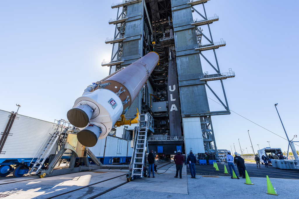
March 14, 2022: NOAA’s GOES-T Reaches Geostationary Orbit, Now Designated GOES-18
On March 14, 2022, GOES-T executed its final engine burn, placing the satellite in geostationary orbit 22,236 miles above Earth. Upon reaching this milestone, GOES-T was renamed GOES-18. NOAA’s GOES-T satellite launched on March 1, 2022, at 4:38 p.m. EST, lifting off from Cape Canaveral Space Force Station in Florida. The satellite launched aboard a United Launch Alliance Atlas V rocket from Space Launch Complex 41. The launch was managed by NASA’s Launch Services Program, based at Kennedy Space Center.
-
March 1, 2022: NOAA’s GOES-T Blasts into Orbit
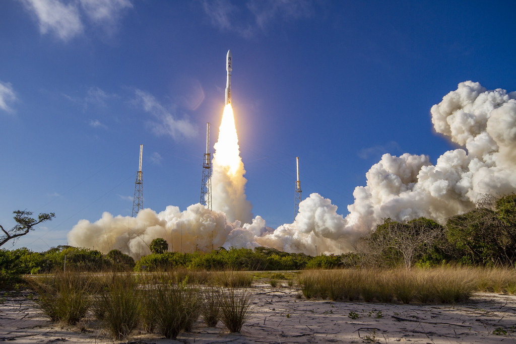
Liftoff of NOAA's GOES-T satellite from Cape Canaveral, Florida, on March 1, 2022 at 4:38 p.m. EST. Photo credit: United Launch Alliance NOAA’s GOES-T, the third in a series of four advanced geostationary weather satellites, blasted into orbit aboard a United Launch Alliance Atlas V 541 rocket at 4:38 p.m. ET today from Cape Canaveral, Florida. After a successful separation from the Centaur upper stage, GOES-T began flying freely. Shortly after, the satellite completed deployment of the stage 1 solar array that will generate electricity for the spacecraft during its mission. GOES-T is orbiting above the Earth, its systems are in good health and it is operating on its own.
-
March 1, 2022: Liftoff! NOAA’s GOES-T Soars Into the Space Coast Sky
A United Launch Alliance Atlas V 541 rocket, carrying NOAA's GOES-T satellite, lifts off from Space Launch Complex 41 at Cape Canaveral Space Force Station in Florida on March 1, 2022. Photo credit: NASA/Kevin O'Connell & Kevin Dav GOES-T lifted off from Space Launch Complex-41 at Cape Canaveral Space Force Station, Florida, on March 1, 2022, at the opening of the launch window at 4:38 p.m. EST. The spacecraft separated from the Centaur upper stage at 8:11 p.m. EST and first stage solar array deployment occurred at 8:28, with power positive confirmed. View additional photos of the GOES-T launch. Watch the United Launch Alliance GOES-T Launch Highlights video. The NASA live GOES-T launch broadcast and commentary show featured live interviews with NOAA and NASA experts and was co-hosted by NOAA’s Kevin Fryar.
March
-
February 28, 2022: GOES-T Rollout to Launchpad
A United Launch Alliance (ULA) Atlas V rocket with NOAA's GOES-T satellite rolls out from the Vertical Integration Facility (VIF) to the launchpad at Space Launch Complex-41 at Cape Canaveral Space Force Station, Florida, on Feb. 28, 2022. Photo credit: United Launch Alliance The United Launch Alliance Atlas V rocket and its GOES-T payload were moved to the launch pad on Feb. 28, 2022, as preparations continue for the March 1 launch from Space Launch Complex 41. View video of the GOES-T rollout. See additional photos in the GOES-T Road to Launch image gallery. NASA Edge provided live coverage of the rollout, including live and pre-recorded interviews with NOAA and NASA experts. Experts interviewed included: Pam Sullivan, GOES-R System Program Director; Ed Grigsby, GOES-R Deputy System Program Director; Dan Lindsey, GOES-R Program Scientist; and Candace Carlisle, GOES-R Flight Project Manager. Watch the NASA Edge Rollout Show.
-
February 26, 2022: GOES-T Pre-launch News Conference

GOES-T pre-launch news conference panelists. Photo credit: NASA/Kim Shiflett The GOES-T pre-launch news conference was held Feb. 26, 2022, at NASA’s Kennedy Space Center in Florida. The briefing featured experts from NOAA, NASA, United Launch Alliance, and Space Launch Delta 45. The briefing was broadcast live on NASA TV and the agency’s website. Media participated virtually. Panelists included: Steve Volz, assistant administrator for Satellite and Information Services, NOAA; Pam Sullivan, director, GOES-R Program, NOAA; John Gagosian, director, Joint Agency Satellite Division, NASA Headquarters Science Mission Directorate; Tim Dunn, launch director, NASA’s Launch Services Program, Kennedy Space Center; Scott Messer, program manager, NASA Launch Services, United Launch Alliance; and Jessica Williams, launch weather officer, 45th Weather Squadron, Space Launch Delta 45. View video of the pre-launch news conference.
-
February 26, 2022: GOES-T Launch Readiness Review
The GOES-T Launch Readiness Review (LRR) was completed on Feb. 26, 2022. The LRR updated the mission status, closed out actions from the Flight Readiness Review and authorized approval to proceed into launch countdown. The Certificate of Flight Readiness (CoFR) was signed at the conclusion of the LRR. GOES-T is a "go" for launch on March 1, 2022.
-
February 25, 2022: Bigger than DishTV, How the Wallops Ground Station Prepares for GOES-T
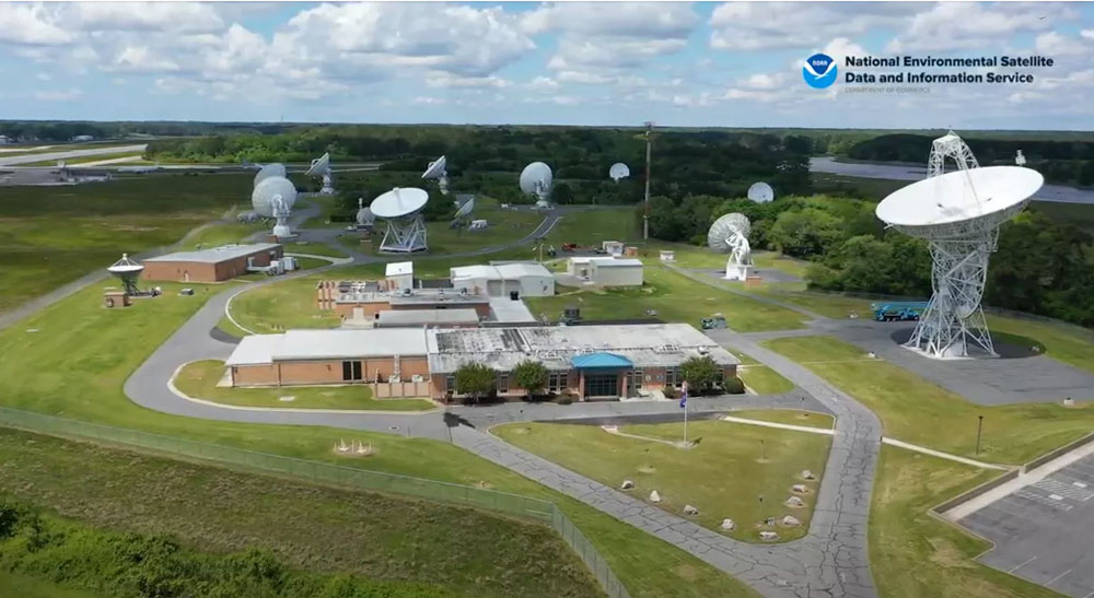
NOAA’s Wallops Command and Data Acquisition Station With the upcoming launch of NOAA’s new GOES-T satellite, staff at ground stations such as NOAA’s Wallops Command and Data Acquisition Station (WCDAS) located at NASA’s Wallops Flight Facility are in full swing preparing for the event. Although Wallops launches smaller rockets as well as research aircraft, unmanned aerial systems, and high-altitude balloons, the facility also supports NOAA’s satellite tracking and commanding capabilities. Learn more about what goes on at Wallops before and after a satellite launch.
-
February 25, 2022: GOES-T Science Briefing
GOES-T science briefing panelists. Photo credit: NASA/Kim Shiflett The GOES-T pre-launch science briefing was held on Feb. 25, 2022 at 1:00 p.m. EST and featured experts from NOAA, NASA, Lockheed Martin and L3Harris. The briefing was broadcast live on NASA TV and the agency’s website. Media participated virtually. Panelists included: Dr. Dan Lindsey, GOES-R Program Scientist, NOAA; Dr. Jim Yoe, Chief Administrator, Joint Center for Satellite Data Assimilation, who participated virtually; Candace Carlisle, GOES-R Flight Project Manager, NASA Goddard Space Flight Center; Tewa Kpulun, Geostationary Lightning Mapper Science Lead, Lockheed Martin; and Dr. Daniel Gall, Advanced Baseline Imager Chief Systems Engineer, Space and Airborne Systems, L3Harris Technologies. View video of the science briefing.
-
February 23, 2022: GOES-T Mission Dress Rehearsal
The GOES-T Mission Dress Rehearsal (MDR) was conducted on Feb. 23, 2022. The MDR was a dry run for launch, allowing the launch team to participate in various simulated launch procedures and activities.
-
February 22, 2022: GOES-T Flight Readiness Review
The GOES-T Flight Readiness Review (FRR) was successfully completed on Feb. 22, 2022. The FRR updated the mission status, closed out actions from the Launch Vehicle Readiness Review and Mission Readiness Review, and certified the readiness to proceed with initiation of final launch preparation activities.
-
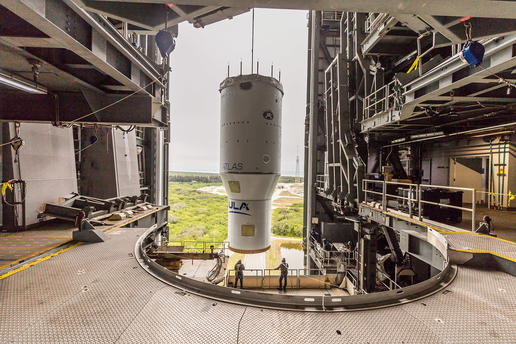
February 18, 2022: NOAA's GOES-T Satellite Road to Launch: Final Preparations

The payload fairing containing NOAA’s GOES-T satellite, secured on a transporter, travels to the United Launch Alliance (ULA) Vertical Integration Facility at Space Launch Complex 41 at Cape Canaveral Space Force Station in Florida. Photo credit: United Launch Alliance A new photo essay highlights the latest operations to prepare GOES-T for launch, including spacecraft encapsulation in its protective fairing, getting the launch vehicle on the stand, and securing the satellite inside its fairing atop the Atlas V rocket. GOES-T is scheduled to launch aboard an Atlas V 541 rocket from Space Launch Complex 41 at Cape Canaveral Space Force Station, Florida on March 1, 2022.
-
February 18, 2022: NASA TV to Air NOAA’s GOES-T Launch, Pre-Launch Activities
NOAA’s GOES-T is scheduled to launch Tuesday, March 1, 20122. The launch, as well as the pre-launch mission and science briefings, and the NASA Edge rollout show, will air live on NASA Television and the agency’s website. At 4:38 p.m. EST on March 1, the two-hour launch window will open, during which GOES-T will launch on a United Launch Alliance Atlas V rocket from Space Launch Complex 41 at Cape Canaveral Space Force Station in Florida. Launch coverage will begin at 4:00 p.m. EST.
-
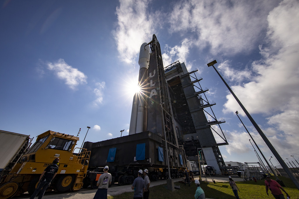
February 17, 2022: GOES-T Mated to Launch Vehicle
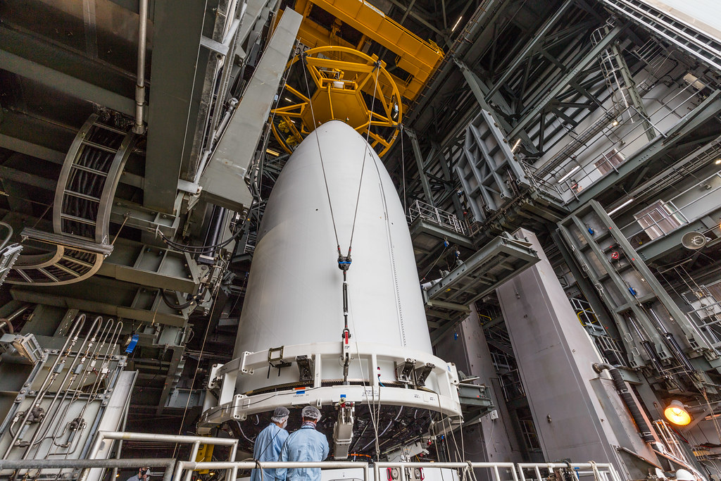
The payload fairing containing NOAA's GOES-T satellite is hoisted into place atop the Atlas V rocket on Feb. 17, 2022. Photo credit: United Launch Alliance. On February 17, 2022, GOES-T, secured inside its payload fairing, was transported from its processing location at Astrotech Space Operations in Titusville, Florida, to the United Launch Alliance Vertical Integration Facility at Cape Canaveral Space Force Station’s Space Launch Complex 41. There, the satellite was raised into position atop the Atlas V rocket that will send it into orbit on March 1. View additional photos of the lift and mate operation.
-
February 16, 2022: GOES-T Launch Bingo
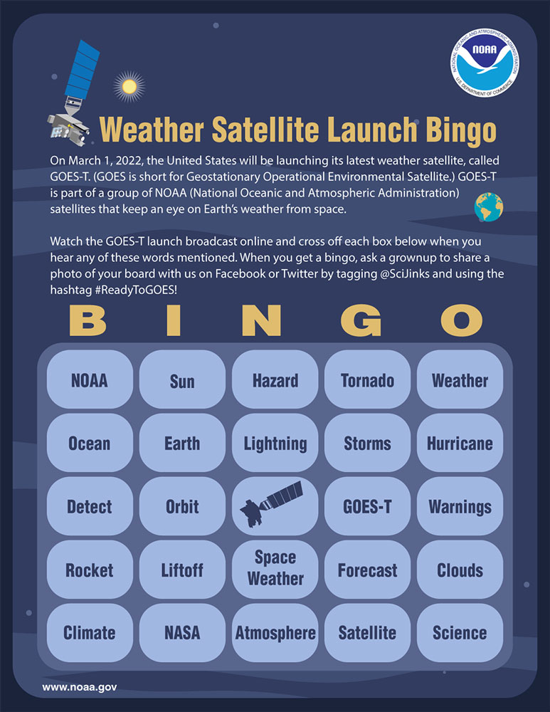
Participate in the GOES-T launch by playing our launch bingo game! Print out the launch bingo cards, watch the GOES-T launch broadcast on NASA TV starting at 4:00 p.m. EST on March 1, 2022, and mark off the words that you hear! Download bingo cards here.
-
February 14, 2022: GOES-T Wildfire Detection and Monitoring
GOES-T will provide critical data for identifying and tracking environmental hazards of particular concern to the western U.S. GOES-T will locate wildfire hot spots, detect changes in fire behavior, predict the motion of fires, estimate a fire’s intensity, and monitor smoke output and air quality effects from smoke. GOES-T can identify the lightning strikes most likely to ignite fires and characterize pyrocumulonimbus clouds that threaten the safety of firefighters.
-
February 11, 2022: GOES-T Encapsulated in Fairing
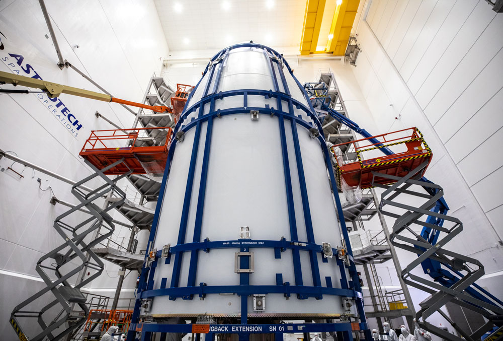
The United Launch Alliance Atlas V payload fairings are secured around the GOES-T satellite inside the Astrotech Space Operations facility in Titusville, Florida, on Feb. 7, 2022. Photo credit: NASA/Ben Smegelsky The GOES-T satellite is now encapsulated the Atlas V fairing. The payload fairing is a specially designed nose cone that, in addition to creating a more aerodynamic profile, encapsulates the satellite, protecting it during the ascent through Earth's atmosphere after launch. GOES-T will soon be moved to Space Launch Complex 41 at Cape Canaveral Space Force Station for mounting atop the Atlas V rocket that will boost the satellite to orbit. Additional photos are available in the GOES-T Road to Launch gallery.
-
February 7, 2022: Centaur Placed Atop Atlas Rocket
The Centaur upper stage is lifted into the Vertical Integration Facility to be placed atop the Atlas V rocket that will launch GOES-T into space. Photo credit: United Launch Alliance The United Launch Alliance (ULA) Centaur upper stage was placed atop the Atlas V booster in the Vertical Integration Facility (VIF) adjacent to Space Launch Complex-41 at Cape Canaveral Space Force Station on Feb. 7, 2022. The Centaur is the launch vehicle’s “brain,” providing guidance and flight control and containing fuel and oxidizer to insert the vehicle into orbit. Additional photos are available in the GOES-T Road to Launch gallery.
-
February 7, 2022: GOES-T Art Challenge Selections Announced
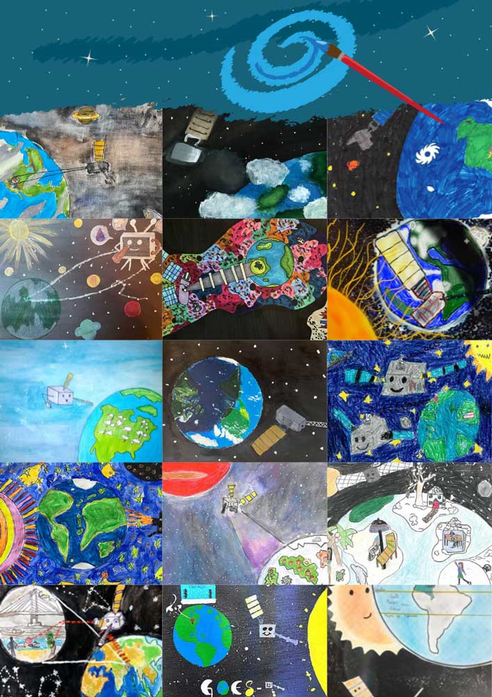
GOES-T art challenge Last month, we challenged kids to draw the GOES-T satellite observing the weather during this time of year where they live. From the hundreds of submissions, we selected 25 to feature.
-
February 3, 2022: Cutting-Edge Instrument Ready to Join NOAA's Space Weather Platform
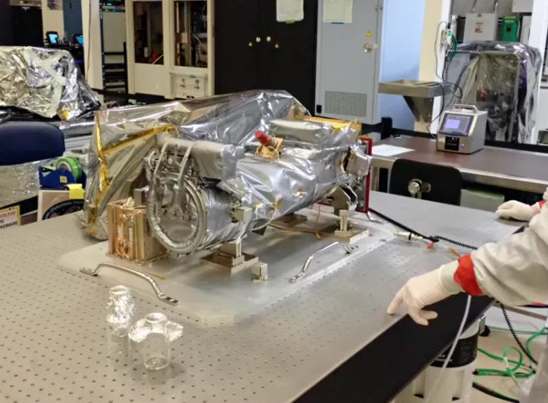
The CCOR-1 instrument is unpacked at Lockheed Martin. A cutting-edge new instrument is ready to be installed on NOAA’s GOES-U satellite, which is scheduled to launch in 2024. The Compact Coronagraph-1 (CCOR-1) instrument was shipped to Lockheed Martin in Waterton, Colorado, after passing its Pre-Shipment Review last month. The team at Lockheed Martin will now begin to install this instrument onto the GOES-U spacecraft. The CCOR-1 will be NOAA’s first-ever solar coronagraph.
-
February 2, 2022: Fog Detection Software Helps Airlines Keep Travelers Safe
GOES-R fog and low stratus product. Image credit: Corey Calvert Fog and low stratus clouds over airports can create dangerous travel conditions that result in costly delays and disrupted travel plans. The U.S. National Weather Service offices monitor and issue warnings when conditions are favorable for the formation of fog and low-level clouds. These warnings are used by the airlines to anticipate conditions, avoid delays and reroute flights if necessary. Now, the NWS uses a new fog detection software developed by scientists at the University of Wisconsin-Madison Cooperative Institute for Meteorological Satellite Studies and NOAA to assist with those warnings. The software uses machine learning techniques with near real-time data from weather satellites like NOAA’s GOES-East and GOES-West to monitor conditions 24/7 and issue potential fog warnings.
-
February 1, 2022: WMO Certifies Two Megaflash Lightning Records
The GOES-16 GLM captured the lightning flash over the southern United States on April 20, 2020 that now holds the world record for the longest distance traveled for a single flash. Image credit: NOAA The World Meteorological Organization (WMO) has established two new world records for megaflashes of lightning in notorious hotspots in North and South America. Aided by the latest satellite technology from the GOES-R Series Geostationary Lightning Mapper (GLM), the WMO recognized the longest distance of a single flash and the greatest duration for a single flash. On April 29, 2020, a mass of severe thunderstorms produced a 477.2-mile-long lightning strike over the southern United States. It stretched from near Houston to southeast Mississippi. The WMO also identified a new world record for the long-lasting lightning flash that lasted for 17.1 seconds over Uruguay and northern Argentina for 17.1 seconds on June 18, 2020. The GLM offers the unique ability to measure lightning flash extent and duration continuously over broad areas.
February
-
January 31, 2022: GOES-T Launch Vehicle on Stand
The Atlas V booster is hoisted into the Vertical Integration Facility. Photo credit: United Launch Alliance The United Launch Alliance (ULA) rocket that will launch GOES-T into space was placed on its stand in the Vertical Integration Facility (VIF) adjacent to Space Launch Complex-41 at Cape Canaveral Space Force Station on Jan. 31, 2022. The Atlas V first stage booster is the backbone of the launch vehicle. It holds the fuel and oxygen tanks that feed the engine for powering the spacecraft into orbit. View additional photos in the GOES-T Road to Launch image gallery.
-
January 31, 2022: NOAA Satellites Helped Save 330 Lives in 2021
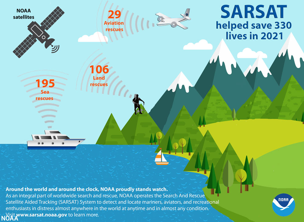
A graphic showing 3 categories of satellite-assisted rescues that took place in 2021: Of the 330 lives saved, 195 people were rescued at sea, 29 were rescued from aviation incidents and 106 were rescued from incidents on land. Image credit: NOAA NOAA’s fleet of advanced satellites are essential for predicting weather and climate, and last year they also helped rescue 330 people from potentially life-threatening situations throughout the United States and its surrounding waters. NOAA’s polar-orbiting and geostationary satellites are part of the global Search and Rescue Satellite Aided Tracking system, or COSPAS-SARSAT, which uses a network of U.S. and international spacecraft to detect and locate distress signals sent from emergency beacons from aircraft, boats and handheld Personal Locator Beacons (PLBs) anywhere in the world. Since its start in 1982, COSPAS-SARSAT has been credited with supporting more than 48,000 rescues worldwide, including more than 9,700 in the United States and its surrounding waters.
-
January 26, 2022: Earth from Orbit: Tongan Eruption Ripples Around the Globe
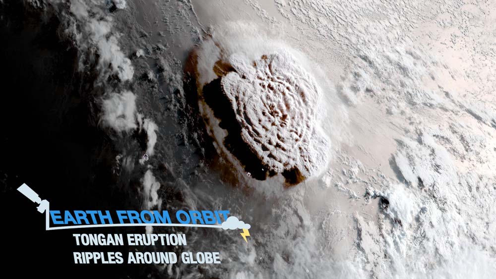
On Jan. 15, 2022 an underwater volcano in the South Pacific Kingdom of Tonga exploded violently in what was likely the largest recorded eruption on Earth in decades. The eruption generated atmospheric shock waves, sonic booms, and tsunami waves that traveled the world and were heard as far away as Alaska. Satellites operated by NOAA and its international partners play a crucial role in detecting volcanic activity, alerting those in harm’s way of an eruption, and monitoring the hazards associated with volcanic eruptions, including volcanic ash and tsunamis.
-
January 24, 2022: Experts to Preview March Launch of NOAA's GOES-T Satellite
Artist's rendering of NOAA's GOES-T, which will provide coverage of the western U.S., Alaska, Hawaii, the eastern and central Pacific Ocean to New Zealand. Image credit: NOAA Experts from NOAA, NASA, United Launch Alliance, Lockheed Martin and L3Harris will hold a virtual media briefing on February 1, 2022, to preview the upcoming launch and mission of NOAA’s GOES-T, the third in a series of four advanced geostationary weather satellites.
-
January 13, 2022: Earth from Orbit: Catching Bolides
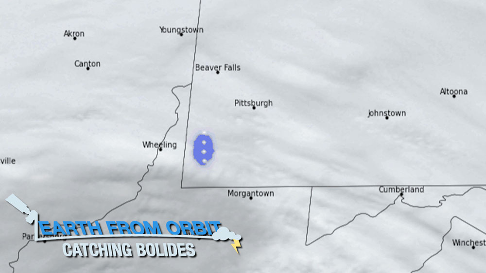
On January 1, 2022, there were numerous reports of sonic booms in southwestern Pennsylvania. GOES-16’s Geostationary Lightning Mapper (GLM) picked up a large flash that wasn’t associated with a thunderstorm. GLM data indicated the source of the mysterious sound to be a bolide, or large meteor exploding in the atmosphere. The GLM onboard GOES-16 and GOES-17 primarily monitors lightning activity. However, it can also detect bolides, and has captured many of these exploding meteors. Loud booms with no visible source can cause a lot of anxiety – especially in populated areas. When GLM is able to quickly confirm the presence of a bolide, it helps calm fears. GLM constantly keeps watch for both lightning and exploding meteor hazards.
-
January 12, 2022: fourth Quarter 2021 GOES-R/GeoXO Newsletter
GOES-T arrives at Kennedy Space Center in November 2021. Photo Credit: NASA/Elizabeth Wilk The GOES-R/GeoXO quarterly newsletter for October – December 2021 is now available. Goodbye to 2021, a challenging year, which did not at all deter the GOES-R/GeoXO team. Our team continues to accomplish outstanding things—achievements made even more impressive because of the pandemic. In the last quarter of the year alone, we delivered GOES-T to Florida and began readying it for a March 1 launch, executed a number of ground system and mission operations rehearsals and tests to prepare for the GOES-T launch, got the brand-new CCOR instrument through thermal vacuuming testing, received approval to formally initiate the GeoXO Program and received concurrence on proposed program and project acquisition strategies. We can’t wait to see GOES-T on-orbit and GeoXO fully in Phase A.
-
January 6, 2022: GOES-T Art Challenge
Meet a GOES-R Series Weather Satellite On March 1, 2022, the United States will be launching its latest weather satellite, called GOES-T. GOES-T is part of a group of NOAA satellites that keep an eye on Earth’s weather from space. Why do we need these weather satellites? The information they collect is used in many ways! In fact, if you’ve ever checked a weather forecast on a phone, computer or television, you’ve used information collected by one of GOES-T’s satellite sisters.
Challenge: Draw the GOES-T satellite observing the typical weather during this time of year where you live! Is it snowy and cold? Is it sunny and warm? Are there storms or lightning?
Need some inspiration? Check out this video and comic book to learn more about weather satellites like GOES-T!
The art challenge is open through Jan. 31. Selected art submissions will appear online and in social media the first week of February.